
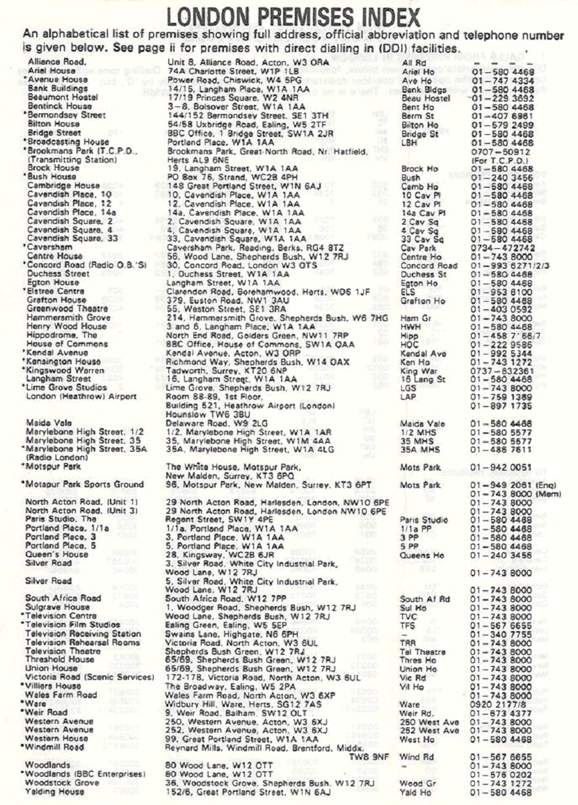
Mike Jordan
This shows how many places the BBC used to inhabit in London alone!
(Click on the picture below to see larger version:
use your Browser’s BACK button to return to this page)
Alasdair Lawrance
This list of premises doesn’t include Redbourne Hostel in New Cavendish Street. I lived there for a short while when I joined in 1963 (it was offered as I had no contacts in the Metropolis), and it turned out to be mainly for admin staff – new secretaries, canteen staff etc. Ever since then, the smell of chips has had a strange effect on me….
Dave Buckley
Looking at the list of telephone number for London premises, the list must be dated 1984 or later as Elstree Centre appears. The BBC bought Elstree at the end of 1983/start of 1984 and my old TV department – TV Training – was the first to move there.
We moved from Woodstock Grove and I see that both WG and Ken House alongside are both on the list. WG is now luxury flats – £1,000,000 or so each, and KH an hotel.
I wonder if anyone staying at the hotel knows why the building is curved? The answer is that the building is built on an old railway line which left the West London Extension Railway just north of Kensington Olympia station and went through what is now Shepherds Bush bus garage, curved south and then west and came up through the running lines of the Piccadilly/District lines west of Hammersmith Station. Some of the brickwork of the viaduct carrying the line can still be seen from the trains on these lines.
Gary Critcher
My first two weeks of actual paid work after I left school was as a holiday relief at the Transcription Service at Ken House in July 1976.
Dave Mundy
I remember doing staff production training courses in WG and seeing the freight trains rumbling past on what is now the Overground from Clapham Junction. There used to be a branch after East Acton which went through, what is now, Wormwood Scrubs car park, and exactly where do the Central lines cross over between SB and White City?
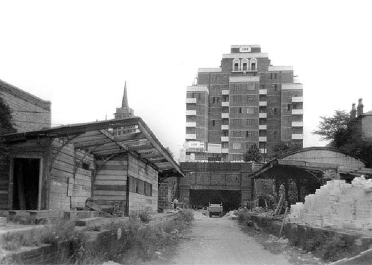
Ian Hillson
(Click on the picture below to see larger version:
use your Browser’s BACK button to return to this page)

The bump in Shepherds Bush Road just outside The Grampians is the old railway bridge of the London and South Western Railway and its station was just to the west of this (not that I remember it!).
(Click on the picture below to see larger version:
use your Browser’s BACK button to return to this page)
Some more photos of the L&SWR station down the years at the bottom of this page:
http://www.disused-stations.org.uk/s/shepherds_
Bernie Newnham, Chris Eames, Mike Jordan, John Howell, Bill Jenkin
Why do the tracks have to cross over either side of Wood Lane on the Central Line?
The original terminus was at Shepherd’s Bush, When they opened Wood Lane station they had to run the trains the ‘wrong way’ round the loop because of the arrangements at Shepherds Bush station and route of the original single track line to take the trains to the depot. The curve under Shepherds Bush Green was built to take passengers better east from the Exhibition (Wood Lane station) without disturbing the tracks into the depot. Basically the tunnels were configured for the loop, and it was probably easier (and cheaper ) not move them, but to put the crossover in after the new station. The reason was to re-establish ‘left-hand running’ to the west of Wood Lane.
Bill Jenkin
The bit I still can’t fathom out is how they manoeuvred the trains from the westbound to the eastbound platforms at Shepherds Bush station when they were loco hauled (which they were until 1902). They would have had to run the loco round the carriages to get to the other end. Then presumably reverse the train across the west crossover points into the reversing siding and back out again onto the eastbound platform. Seems a bit complicated to me.
Chris Pocock
I just happen to have a book “Rails Through the Clay – A History of London’s Tube Railways” on loan from a friend …and found the attached which might throw some light on your query.
“…The original CLR line from Shepherd’s Bush station to Wood Lane, for depot access only, ran west from the station under the Uxbridge Road and Shepherd’s Bush Green, turning sharply north on a 200ft radius curve (‘Caxton Curve’) to follow the alignment of Caxton Road in a single line tunnel. When the passenger service was extended to Wood Lane in 1908, the new (eastbound) line was taken well to the west of Caxton Curve, running along the east side of Wood Lane to allow it to connect with a loop in the depot. With an easier curve, it cut across Bulwer Street and Aldine Street to pass beneath the westbound tunnel under the Uxbridge Road and continue into Shepherd’s Bush eastbound platform. Much of the new line was under CLR property. The lines north of Wood Lane had therefore to be crossed back again to permit normal left-hand running.
Warwick Cross
This PDF map of Wood Lane shows the loop round the old Wood Lane Station and depot.
Notice also that there is a junction on the Hammersmith & City Line just south of Latimer Road station and there are tramways running all the way down the centre of Wood Lane itself as well as around the Olympic Stadium.
Alec Bray
The viaduct – or curved ramp down from Latimer Road – was still there in the late 1960s – seen regularly on my regular journey to work. It was part of the “middle” circle of “underground” circular routes – the “inner circle” now being the new question mark (or spiral) (yellow) route, the middle circle – and there was an outer circle as well.
from Wikipedia:
“… GWR began a "middle circle" service from Moorgate to Mansion House via Latimer Road and Earl’s Court. [This was] cut back to Earl’s Court in 1900 for the "middle circle" and 1909 for the "outer circle". The GWR service survived as a shuttle service from the Hammersmith & City line to Addison Road [now Kensington (Olympia)] until 1940….”
Mike Jordan
Don’t forget this brilliant web page (quite safe – from National Library of Scotland) which shows side-by-side various old and current maps with two matching pointers.
http://maps.nls.uk/geo/explore/sidebyside.cfm#zoom=16&lat=51.5104&lon=-0.2268&layers=171&right=BingHyb
Shows the development therefore of all the TC sites.
You can see the start of the Ladbroke Grove to Olympia bit from the tube at Ladbroke Grove.
Dave Buckley
I note from the maps shown in the link above that Woodstock Grove (next to Ken House) was originally called Woodstock Road!
Overall, fascinating, particularly when I went out to the suburbs (Wembley Park, Central Harrow) and found that the houses I have lived in hadn’t been built! Not surprising as the map covers 1888 -1913 and most of the urban development was between the two wars, although the date of one of the properties was 1901, so the map probably hadn’t been updated.
Alasdair Lawrance
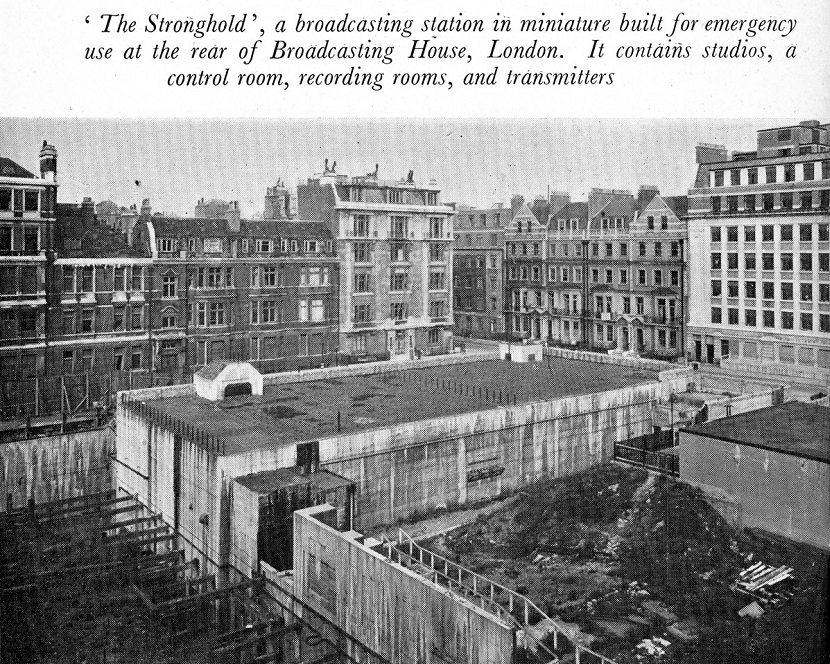
I have “London’s Secret Tubes”, by Andrew Emmerson and Tony Beard. There are two bits of info regarding BH which I didn’t know: one was a plan to extend the building along Gt. Portland Street to Duchess Street and the other was a plan to build a wartime underground base called ’The Stronghold’. This was apparently revealed in the 1946 Handbook.
John Howell
Here is a picture from the 1946 Yearbook:
(Click on the picture below to see larger version:
use your Browser’s BACK button to return to this page)
Tony Scott
The Stronghold plan did, in fact, happen
http://www.orbem.co.uk/misc/stronghold.htm
http://www.miketodd.net/other/bhhistory/wartime/stronghold01.htm
The Stronghold was entered through gas- and flame-proof doors, which led via steps and short passages, to the main central corridor.
The Stronghold housed four studios and cubicles which were used as store rooms in later years. Other areas in the complex were converted to echo rooms.
The Stronghold also included the oft-mentioned "staircase to nowhere". At the bottom of the stairs was a small white painted space with no further doors.
Alasdair Lawrance
Also quoted in the book:
“… Radio Pictorial magazine reported in May 1938 that preparations were well underway for gas-proofing the underground tunnels leading from BH, where, three floors below ground, the air-conditioning pumps were being made gas-proof. The artesian well in the basement of BH, although sealed, could be opened within half-an-hour, and this would provide the continuous supply of filtered water necessary for producing oxygen by chemical means in the gas plant…”
That’s an interesting proposition! (Drainage, CO2 removal).
Mike Jordan
The story of the well is that it was also used as the BH earth connection and one day, when BH technical earth went “noisy” it was traced back and found the cable dropping into the well had corroded away so there was no proper earth. They just joined a new length on and all came good (quiet).
Bill Jenkin
Of course the extension to Duchess St. was in two parts, BHX & BHXX. BHX housed London Control Room amongst other things.
It’s been demolished to make way for ‘New’ BH which sort of wraps itself round the back of the original building. In fact you can see the outside of what was the original North wall of BH in the new building.